Introduction: Why Scan to BIM Matters
Buildings and infrastructure rarely stay the same as the drawings show. People add renovations, extensions or change services over time. Sometimes construction mistakes or simple changes happen that no one writes down. These things create gaps between the design papers and the actual building. This is why Scan to BIM is such a way to work.
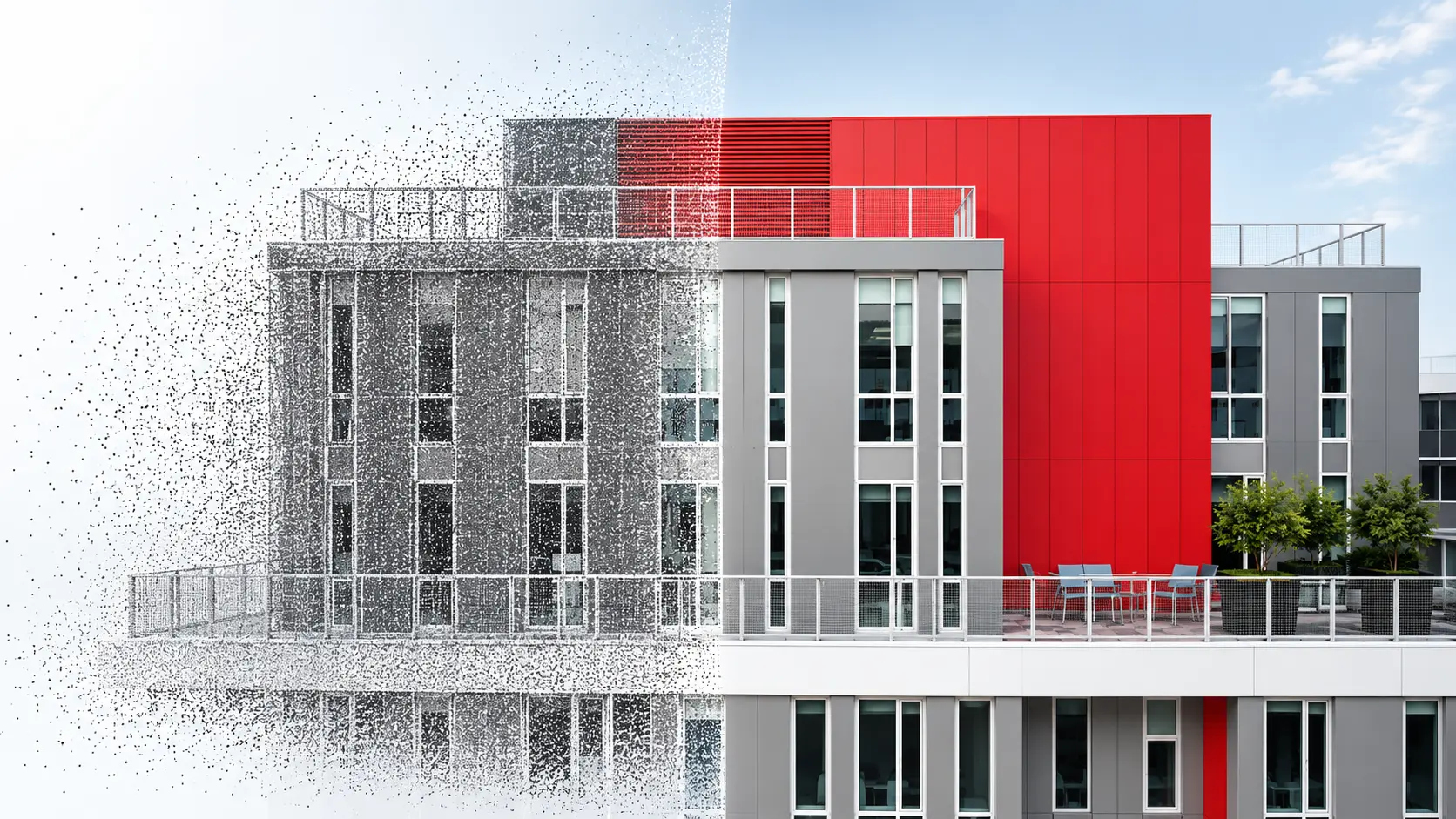
Scan, to BIM brings together 3D laser scanning, point-cloud processing and Building Information Modeling (BIM) to turn a building into a smart digital model. I have seen that teams cannot just rely on drawings or manual measuring anymore. Instead project teams can scan the space work with the point cloud data and use that data to build a very accurate BIM model.
What is Scan to BIM?
Scan to BIM is the process of taking an existing building or site using reality capture tools and turning the captured data into a BIM model.
The workflow usually starts with laser scanning. The scanner records millions of points that show surfaces, geometry and spatial relationships. These points are put together into a point cloud. The point cloud is then registered, cleaned organized and prepared for scan to BIM modeling. Finaly BIM software such as Autodesk Revit can be used to create model elements that represent the existing asset.
The key difference between a point cloud and a scan to BIM model is intelligence. A point cloud mainly shows captured geometry while a scan to BIM model holds objects such, as walls, doors, floors, columns, beams, pipes and equipment plus parameters and other data.
The Scan to BIM Workflow
- Project Planning: Define the survey area, required accuracy, project scope, BIM requirements, LOD, coordinate system and expected deliverables.
- 3D Laser Scanning: Capture the existing building or site using terrestrial laser scanners or other suitable reality-capture equipment.
- Scan Registration: Combine individual scans into a common coordinate system so the surveyed environment can be viewed as one dataset.
- Point Cloud Processing: Clean noise, remove unwanted data, organize scans and prepare the point cloud for downstream BIM use.
- Point Cloud Review: Inspect the point cloud to understand existing geometry and identify modeling requirements.
- BIM Modeling: Use the point cloud as a reference to model architectural, structural and MEP elements in the selected BIM platform.
- Model Validation: Compare the BIM model against the point cloud to identify significant discrepancies and verify modeling accuracy.
- BIM Delivery: Deliver the coordinated as-built BIM model and associated information in the required formats.
3D Laser Scanning: The Foundation of the Workflow
3D laser scanning is a technology that captures reality by measuring the environment using many spatial points. Also 3D laser scanning can record walls, floors, ceilings, structural members, equipment, openings and building services with geometric detail.
The 3D laser scanning job must be planned with care. Accuracy, coverage, coordinate requirements and BIM deliverables all matter. Scanner positioning, registration quality, field conditions and the tolerances you set all affect how useful the final data set will be.
What Is a Point Cloud?
A point cloud is a group of millions or even billions of points that show surfaces that were recorded during a survey or a scan. Each point can have location details. Might also have other data like strength or color based on the way it was recorded.
Point clouds offer a detailed digital look, at what is already there. They are not automatically BIM models. A point cloud still has to be understood and changed into BIM parts when a project needs a smart model.
Point Cloud to BIM: Converting Reality into Information
Point cloud to BIM is the core modeling stage of the Scan to BIM process. BIM technicians and modelers use the registered point cloud as a visual and geometric reference while creating model elements.
- Architectural elements: walls, floors, ceilings, roofs, doors, windows and stairs.
- Structural elements: columns, beams, slabs, foundations and structural frames.
- MEP elements: ducts, pipes, cable trays, equipment and other visible building services.
- Specialized elements: façades, heritage features, industrial equipment and infrastructure components.
Laser Scanning BIM: Accuracy Meets Information Modeling
The modeling approach should follow the required deliverable, model purpose and project standards. Not every visible feature needs to be modeled at the same level of detail.
Laser scanning BIM brings real-world data together with organized BIM information. This mix is very helpful for projects like renovations upgrades, updates, fixing buildings, managing buildings and any work where it’s hard to find correct information from old papers.
Then guessing the design team can use real measurements of what is already there. This helps surprises during the planning stage and makes it easier to match what is already in place, with what is being planned.
ReCap to Revit: A Common Workflow
A common Autodesk-based workflow is ReCap to Revit. ReCap can be used to process and prepare point-cloud data, while Revit can use the resulting point cloud as a reference for BIM modeling.
- Process and organize scan data.
- Register and review individual scans.
- Clean and classify point-cloud data where required.
- Establish the appropriate coordinate and project reference system.
- Link or reference the point cloud in Revit.
- Create BIM elements by interpreting the surveyed geometry.
- Validate the model against the point cloud before delivery.
Point Cloud Revit: How the Modeler Uses the Data
Using point Revit workflows lets modelers see real-world conditions right inside the BIM environment. You can use the point cloud as a guide while you build walls, slabs, structural elements, ceilings, doors, windows and MEP systems.
Good modeling practice is about more, than tracing every single point you see. A modeler needs to think about how the building works understand how different parts fit together and follow the project modeling standards.
Applications of Scan to BIM for Renovation and Construction
Scan to BIM is a technique where laser scanning point cloud data is converted into BIM models that depict the reality of the situation. Scan to BIM technique can prevent problems resulting from outdated drawings and offers a solid base for projects.
| Application Area | How Scan to BIM is Used | Benefits in Renovation & Construction | ||
| Existing Condition Capture |
|
Eliminates manual measurement errors and provides highly accurate base models | ||
| Point Cloud to BIM Modeling | Point cloud data is converted into parametric BIM elements (walls, floors, MEP systems) | Creates intelligent models for better design decisions and coordination | ||
| Renovation & Retrofit Planning | Engineers review existing constructions prior to any changes to layouts or installations. | Minimizes risk and guarantees compatibility with current building components | ||
| Clash Detection & Coordination | BIM models from scan data are used to detect clashes between structural, MEP, and new work | Minimizes conflicts and reduces costly rework during construction | ||
| As-Built Documentation | Validation of Project Accuracy through Comparison of Final Constructed Model with Scanned Data | Ensures project quality and compliance with design intent | ||
| Quantity Takeoff & Estimation | Accurate BIM models enable extraction of quantities for materials and cost estimation | Improves budgeting accuracy and reduces material wastage |
Skills Needed for Scan to BIM
- 3D Laser Scanning & Data Acquisition
1.LiDAR principles knowledge
- Scanning equipment setup and positioning
- Accuracy and resolution handling
- Point Cloud Processing
- Scan registration & alignment
- Noise reduction & cleaning
- Working with RCP & E57 files
- BIM Modeling
- Modeling architectural, structural and MEP components
- LOD 100-500 modeling
- Family creation
- BIM Standards & Documentation
- Basics of ISO 19650
- BIM Execution Plan (BEP)
- Naming convention & data structure
- Clash Detection & Coordination
- Clash detection running
- Reports interpretation
- Multi-discipline coordination
- Construction & MEP
- Electric installations
- Heating, Ventilation & Air Conditioning
- Plumbing
- Quality Control & Accuracy Control
- BIM vs Scan comparison
- Tolerance control
- Automation & Advanced Skills
- Dynamo for Revit
- Automated Scan to BIM solution based on AI
Scan to Revit: From Survey Data to a BIM Model
Scan to Revit is the real-world process of taking scanned data and point clouds and using that data to build a Revit model. I find that Scan to Revit is a help when you are working on old buildings that do not have good CAD drawings or BIM models to look at.
The final Revit model will hold both the shape of the building and important details. Depending on what the project needs the Revit model might include things, like element categories, materials, dimensions, room data, equipment parameters and other details you need.
As-Built BIM: Creating a Digital Record of Existing Conditions
One of the uses of Scan to BIM is as‑built BIM. An as‑built BIM model shows the state of an asset, after construction or when a survey is done, within the limits of the projects scope and accuracy.
For facility owners an accurate as‑built BIM model can help with renovation planning, maintenance, space management, asset documentation and future project development.
Where Scan to BIM Is Used?
- Existing building documentation
- Renovation and refurbishment projects
- Building extensions and retrofit projects
- Heritage and historic building documentation
- Industrial facilities and plants
- MEP retrofit and coordination
- Infrastructure and transportation projects
- Facility management and asset documentation
- Construction verification and quality control
Benefits of Scan to BIM
- Improved understanding of existing conditions
- Reduced dependence on incomplete legacy drawings
- Faster and more reliable spatial data collection
- Better coordination between existing and proposed design
- Improved visualization of complex spaces
- Support for renovation and retrofit planning
- A structured digital asset record for future use
- Better communication between survey, design, construction and facility teams.
Challenges in Scan to BIM Projects
Scan to BIM works well. The quality of the final BIM model depends on every single step, in the process. If the scanning does not cover the area or if there are mistakes when matching the scans together then the result will not be good. If the coordinate systems are not right or if the data is missing or if the modeling rules are not followed then the final BIM model will be bad.
- Large point-cloud file sizes and data management
- Occlusions and inaccessible areas during scanning
- Registration and coordinate-system issues
- Ambiguous or hidden building elements
- Different accuracy requirements for different model elements
- Time required for detailed BIM modeling
- Need for experienced scan technicians and BIM modelers
- Clear definition of scope, LOD and model accuracy requirements
Scan to BIM Accuracy and Level of Detail
Accuracy must be defined before scanning and modeling begins. A project may need levels of accuracy for architectural, structural and MEP elements. The required BIM Level of Development (LOD) the purpose of the model and the information requirements of the project should guide the modeling process.
When a facility‑management model is considered the model prioritizes asset information and maintainability. When a renovation project is considered the project requires accurate geometry, around specific building areas. Therefore the detailed possible model is not always the best model. The correct model is the one that meets its use.
Scan to BIM vs. Traditional Survey and CAD
| Aspect | Traditional Approach | Scan to BIM Approach |
| Data capture | Manual measurements and drawings | 3D laser scanning and reality capture |
| Existing geometry | Selected measurements | Dense spatial point data |
| Model creation | CAD drafting or manual BIM modeling | Point-cloud-supported BIM modeling |
| Coordination | Based on available drawings | Based on captured existing conditions |
| Future use | 2D documentation | Structured BIM and asset information |
Best Practices for a Successful Scan to BIM Project
- Define project scope and BIM deliverables before scanning.
- Establish survey accuracy and coordinate requirements in advance.
- Plan scan locations to minimize blind spots and occlusions.
- Maintain consistent registration and quality-control procedures.
- Use appropriate point-cloud formats and data-management practices.
- Set clear modeling rules for each discipline.
- Define LOD, model accuracy and information requirements.
- Validate the completed model against the point cloud.
- Document areas that could not be surveyed or modeled with confidence.
The Future of Scan to BIM
The future of Scan to BIM is moving toward faster reality capture, automated feature recognition, AI-assisted modeling and greater integration with twins.
Artificial intelligence and computer vision can potentially help identify walls, doors, pipes, equipment and other elements within point clouds reducing manual modeling tasks.
Conclusion
As BIM becomes increasingly connected to facility management and digital-twin platforms scan data can also support verification of existing assets.
The workflow is evolving from a one-time survey-to-model task into a method for maintaining reliable digital information, about the built environment.
Scan to BIM creates a link between the real world and the digital built environment. By using 3D laser scanning point clouds and BIM modeling project teams can build digital copies of existing buildings and infrastructure.
From point cloud to BIM and from ReCap to Revit the workflow lets professionals move from raw reality‑capture data to BIM information. When the process is properly planned, checked and matched to project needs Scan, to BIM can help improve design coordination, renovation planning, construction choices and long‑term asset care.
Frequently Asked Questions:
How does point cloud to BIM work?
Point cloud to BIM is a methodology aimed at transforming three-dimensional laser scanning data into a digital intelligent building model. Point cloud to BIM starts with acquiring the site conditions by means of a 3D laser scanner. The latter captures millions of points on surfaces, such as walls, floors, and structural components. The result is a dataset of points that form a point cloud, which represents the true geometry of the environment. The scan data is further processed and registered in Autodesk ReCap software through alignment and optimization of scan data positions into one file. The point cloud obtained after the processing step is imported into a BIM tool, for example, Autodesk Revit, where the former is used as a reference background for tracing over. In point cloud to BIM, there is no conversion of points into BIM models automatically; it is done manually. The final product of point cloud to BIM is a highly precise as-built BIM model, which can be used for renovation, coordination, facility management, and documentation purposes.
What Is Point Cloud Data?
Point clouds represent the raw data obtained as a result of 3D laser scanning. The data is represented by millions of points in the 3D coordinate system. Each point represents a certain spot on the surface with its exact location. In addition to this, many points have the information related to their color represented by RGB values. Taken together, point clouds provide highly detailed representation of the scanned area. This data forms the basis of further creation of BIM models.
Can Revit open point clouds?
Yes, point clouds can be used with Autodesk Revit, but it neither opens nor edits them like any other BIM file. Rather, Revit enables users to import point cloud files in .RCP and .RCS formats to work with them as a reference model in the project. In fact, before being imported into Revit, the point cloud files are usually processed by another application from Autodesk Inc. called ReCap, where laser scan data is preprocessed and converted into a convenient form. Being imported to Revit, a point cloud is used as an extremely precise representation of reality that is used for creating intelligent BIM models using section boxes and snapping tools for tracing and modeling architectural, structural or MEP systems.
What is the difference between Scan to BIM and BIM?
The major differences between the two concepts arise from their purposes and application stages in the development process. While Building Information Modeling (BIM) refers to an extensive digital methodology aimed at designing and managing the building project by employing intelligent 3D models which include geometrical and non-geometrical data from the beginning of development (planned or conceptual stage), Scan to BIM is a more targeted concept which is used when developing existing buildings. In other words, Scan to BIM is applied when real-life measurements and features of the building are measured through 3D laser scanning and transformed into a BIM model. Therefore, it can be concluded that BIM is a tool for digital modeling of building projects, whereas Scan to BIM is a tool for transforming physical reality into the BIM model.
Is Scan to BIM in demand?
Of course, there is high demand for Scan to BIM in today’s AEC industry. Thanks to the development of various digital construction technologies, the process of 3D laser scanning and BIM application is becoming more popular among different organizations due to accuracy, lack of mistakes, and saving time during renovation, retrofitting, and infrastructure construction. Especially Scan to BIM has become extremely popular for those buildings where there are no initial drawings because of their loss or aging. There are lots of studies and reports that claim that Scan to BIM is becoming a part of common practice in many projects and is used in facility management, clash detection, and construction planning. The more popular BIM is around the world, the greater is demand for professionals who can work with Scan to BIM.